Advanced Aerial Solutions
Drone Thermal Inspection Services
At EDPS Consulting, we harness cutting-edge drone technology to deliver precise, efficient, and safe thermal inspections across a variety of industries.
Our UAV (Unmanned Aerial Vehicle) thermal imaging services provide high-resolution data that helps identify potential issues before they become costly problems—saving you time, money, and risk.
Why Choose Our Drone Thermal Inspection Services?
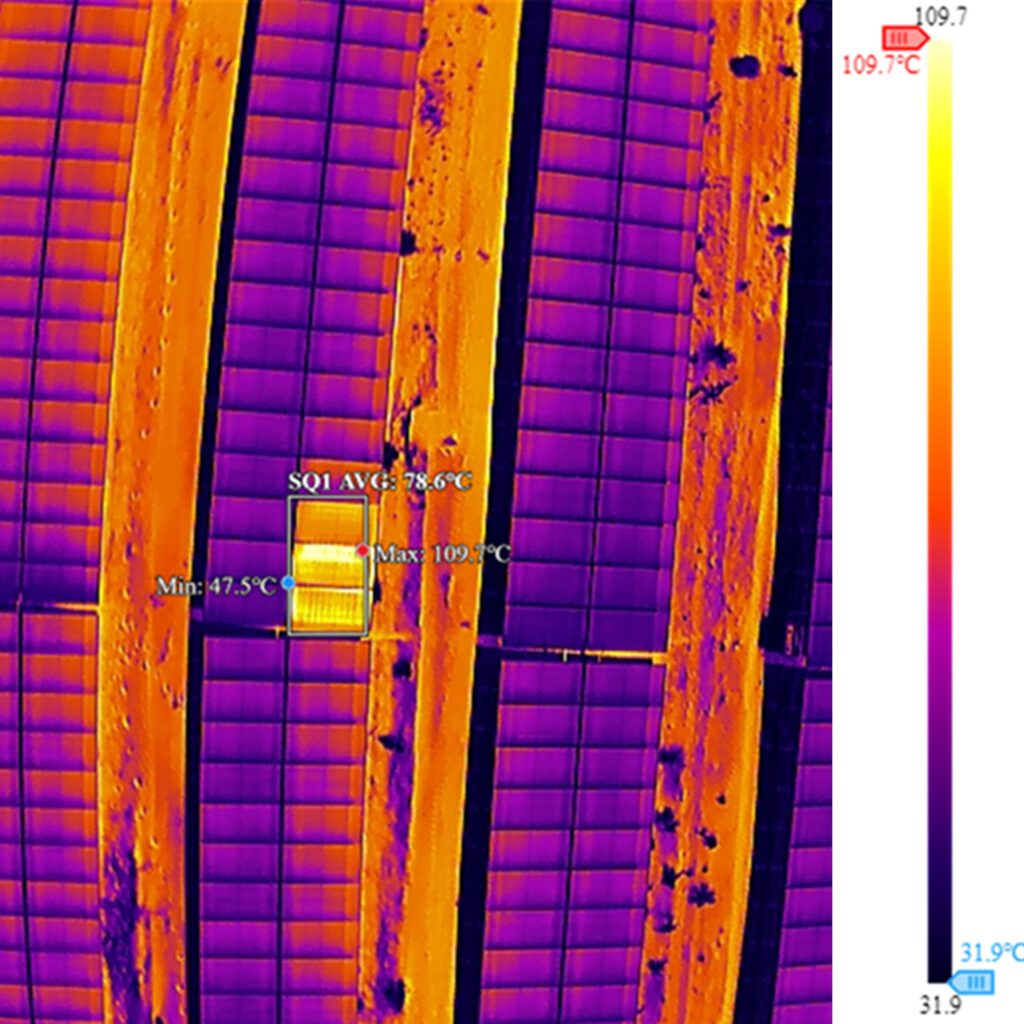
High-Resolution Thermal Imaging
High-Resolution Thermal Imaging
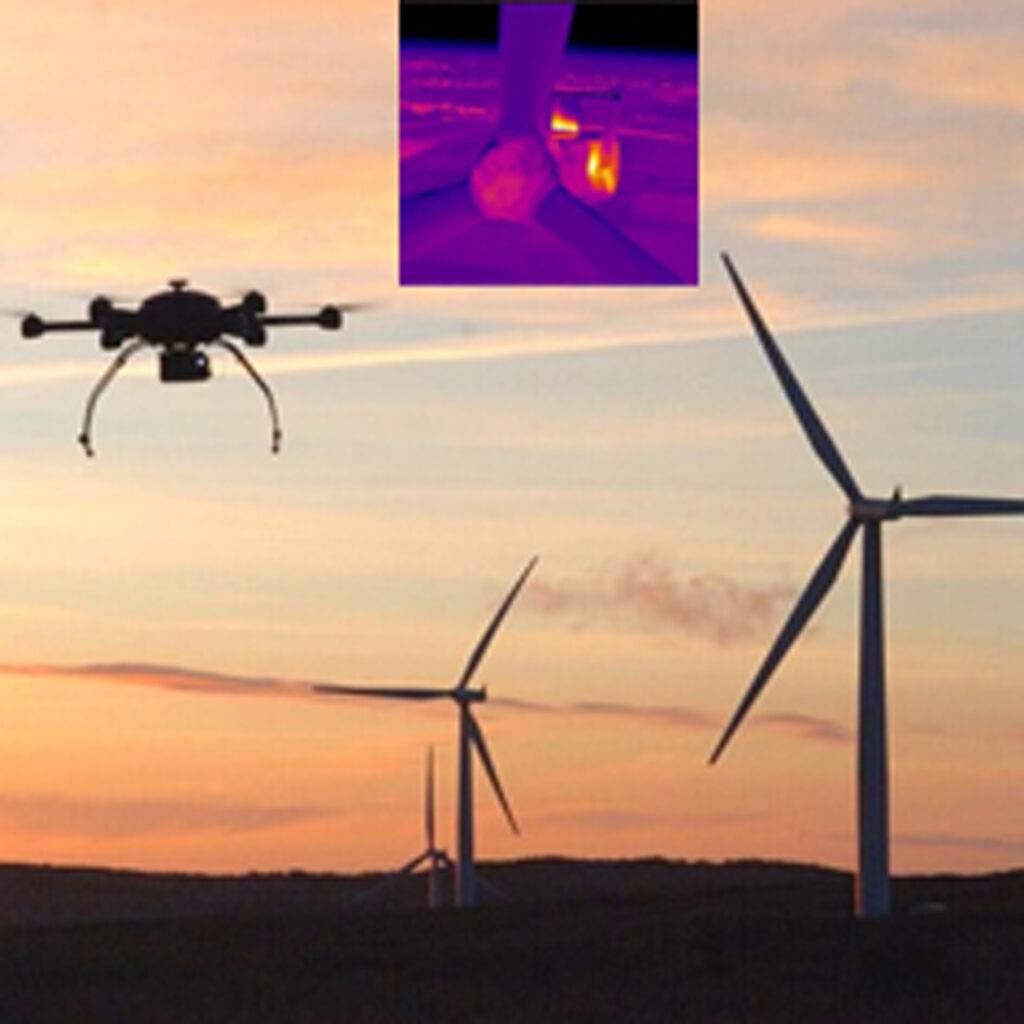
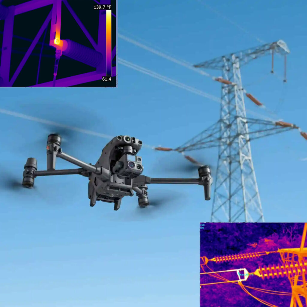
- We use advanced infrared cameras mounted on drones to detect heat anomalies with pinpoint accuracy. This allows for fast and non-invasive identification of electrical faults, moisture intrusion, insulation issues, and more.
Safe and Non-Disruptive Inspections
- Our drone inspections eliminate the need for scaffolding, ladders, or dangerous manual methods. Sites remain fully operational during inspection, minimizing downtime and disruption.
Comprehensive Reporting
- EDPS Consulting delivers detailed, easy-to-understand thermal analysis reports with actionable insights. Our team of certified professionals ensures data accuracy and integrity.
Industry Applications
- Electrical & Solar Installations: Detect faulty panels, loose connections, or overheating components.
- Building & Roof Inspections: Identify leaks, poor insulation, or structural defects.
- Industrial Facilities: Prevent costly breakdowns by monitoring critical equipment.
- Utilities & Infrastructure: Survey power lines, substations, and pipelines with precision.

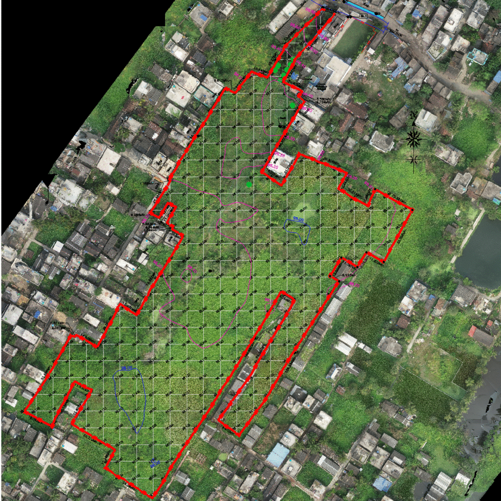
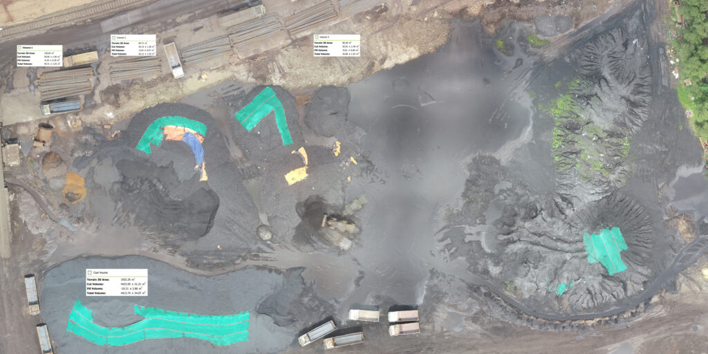
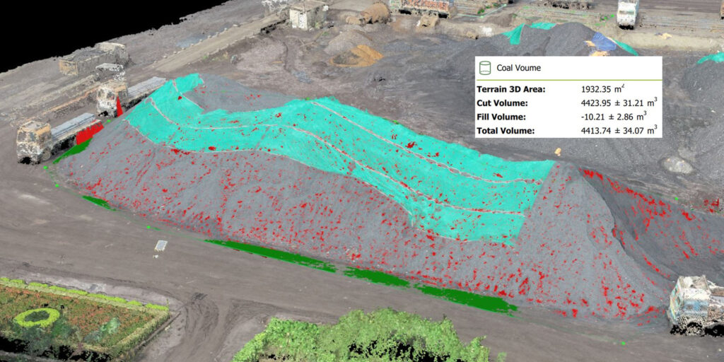
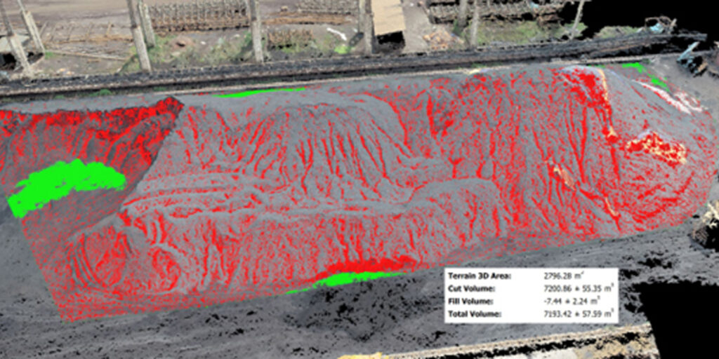
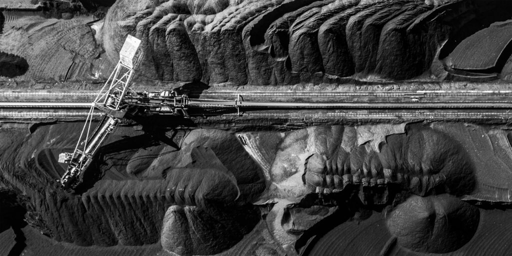
Ortho-mosaic Volumetric Calculation & Mapping Services
At EDPS Consulting, we specialize in providing high-accuracy drone surveying and ortho–mosaic mapping with volumetric analysis. Whether you’re managing construction, mining, agriculture, or land development projects, our drone-based services offer a faster, safer, and more cost-effective alternative to traditional ground surveys.
Our Drone Surveying Capabilities
We utilize high-resolution aerial imagery and GPS-integrated flight systems to produce detailed and georeferenced ortho–mosaic maps, 3D models, and elevation data. These datasets are ideal for precise planning, design, and ongoing project monitoring.
Orth-Mosaic Mapping
- High-resolution, true-colour aerial images stitched into seamless, georeferenced maps.
- Ideal for land use planning, progress tracking, and visual documentation.
- Accuracy within centimeters, suitable for engineering-grade decisions.
Volumetric Calculations
- Accurate volume measurements for stockpiles, cut & fill sites, and earthworks.
- Monitor material movement, optimize logistics, and prevent over- or underestimation.
- Regular surveys enable historical comparison and project trend analysis.
Indian Bureau of Mines (IBM) Submission
- Drone Survey & GCP Establishment: drone surveys and establish Ground Control Points (GCPs) as per DGPS standards to ensure spatial accuracy.
- Data Processing & Map Preparation
Develop Digital Surface Models (DSM), Digital Terrain Models (DTM), and prepare base maps. - Map Digitization: Digitize processed maps to define mining lease activities such as excavation, waste disposal, and afforestation areas.
Mining Lease Area Map (WGS 84 Datum with UTM projection)
- Actual excavations (mineral and waste)
- Mineral storage areas
- Subgrade dumps
- Waste dumps
- Afforestation areas
- Reclaimed/backfilled zones (for the preceding financial year)
- Rest and toe positions of quarries and dumps
Why EDPS Consulting?
- Precision & Accuracy
Our drones capture data with centimeter-level precision using RTK/PPK technology.
- Trained Personal
Certified drone operators with specialized training in thermal imaging.
- Safety Regulations
Compliance with aviation and safety regulations.
- Rapid Turnaround
Get results within hours to a few days—significantly faster than traditional surveys.
- Cost-Effective & Scalable
Reduce labour and equipment costs. Our solutions scale from small to large sites seamlessly.
- Safe & Non-Intrusive
Survey hazardous or hard-to-reach areas without putting personnel at risk.
Industries We Serve
- Mining & Quarrying
- Oil & Gas Infrastructure
- Power & Renewable Energy
- Agriculture & Land Management
- Infrastructure & Construction
- Environmental Monitoring & Site Restoration
Let’s Elevate Your Project
From pre-construction surveys to ongoing volumetric assessments, EDPS Consulting delivers the insights you need—faster, safer, and more accurately.